Executive Committee Range
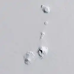 Executive Committee Range – zdjęcie satelitarne (2014) | |
| Kontynent | |
|---|---|
| Najwyższy szczyt |
Mount Sidley |
| Długość |
80 km |
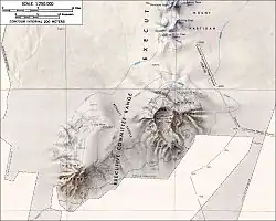 Mapa południowej części pasma | |
Położenie na mapie Antarktyki  | |
Executive Committee Range – góry wulkaniczne w północnej części Ziemi Marii Byrd w Antarktydzie Zachodniej.
Nazwa
Nazwa upamiętnia Antarctic Service Executive Committee – komitet wykonawczy US Antarctic Service[1]. Poszczególne góry – poza szczytem Mount Sidley – nazwane są na cześć członków komitetu[1].
Geografia
Pasmo pochodzenia wulkanicznego w północnej części Ziemi Marii Byrd w Antarktydzie Zachodniej[2]. Zbudowane jest z bazaltów i tufów wulkanicznych z okresu kenozoiku[2]. Do wysokości ok. 2500 m pokryte jest lądolodem[2].
Tworzy je pięć głównych szczytów leżących wzdłuż południka 126°W na przestrzeni 80 km[1]; patrząc z południa na północ:
- Mount Waesche (3290 m n.p.m.)[3]
- Mount Sidley (4285 m n.p.m.[4]) – najwyższy szczyt pasma[2] i najwyższy wulkan Antarktydy[5], który jeszcze nadal może jest aktywnym wulkanem[6]
- Mount Hartigan (2800 m n.p.m.)[7]
- Mount Cumming[8]
- Mount Hampton (3325 m n.p.m.)[9]
Aktywność wulkaniczna nie wygasła tu całkowicie, o czym świadczą trzęsienia ziemi zarejestrowane w 2010 i 2011 roku, z epicentrum ok. 55 km na południe od Mount Sidley[10].
Historia
Pasmo zostało odkryte 15 grudnia 1940 roku w czasie lotu ekspedycji United States Antarctic Service[1]. Zostało szczegółowo zmapowane przez United States Geological Survey na podstawie badań terenowych i fotografii z powietrza w latach 1958–1960[1].
Przypisy
- 1 2 3 4 5 SCAR Composite Gazetteer of Antarctica and United States Gazetteer ↓.
- 1 2 3 4 Encyklopedia PWN ↓.
- ↑ SCAR Composite Gazetteer of Antarctica and United States Gazetteer – Mount Waesche ↓.
- ↑ SCAR Composite Gazetteer of Antarctica and United States Gazetteer – Mount Sidley ↓.
- ↑ Hund 2014 ↓, s. 730.
- ↑ Smellie i Edwards 2016 ↓, s. 22.
- ↑ SCAR Composite Gazetteer of Antarctica and United States Gazetteer – Mount Hartigan ↓.
- ↑ SCAR Composite Gazetteer of Antarctica and United States Gazetteer – Mount Cumming ↓.
- ↑ SCAR Composite Gazetteer of Antarctica and United States Gazetteer – Mount Hampton ↓.
- ↑ Lough i inni 2013 ↓.
Bibliografia
- Executive Committee Range (United States Gazetteer). W: Scientific Committee on Antarctic Research (SCAR): SCAR Composite Gazetteer of Antarctica. (ang.).
- Executive Committee, [w:] Encyklopedia PWN [online], Wydawnictwo Naukowe PWN [dostęp 2022-04-19].
- Hund, Andrew J.: Antarctica and the Arctic Circle: A Geographic Encyclopedia of the Earth's Polar Regions. ABC-CLIO, 2014. ISBN 978-1-61069-393-6. [dostęp 2022-04-15]. (ang.).
- Lough, A., Wiens, D., Grace Barcheck, C. et al.. Seismic detection of an active subglacial magmatic complex in Marie Byrd Land, Antarctica. „Nature Geoscience”. 6, s. 1031–1035, 2013. DOI: 10.1038/ngeo1992. (ang.).
- Mount Cumming (United States Gazetteer). W: Scientific Committee on Antarctic Research (SCAR): SCAR Composite Gazetteer of Antarctica. (ang.).
- Mount Hampton (United States Gazetteer). W: Scientific Committee on Antarctic Research (SCAR): SCAR Composite Gazetteer of Antarctica. (ang.).
- Mount Hartigan (United States Gazetteer). W: Scientific Committee on Antarctic Research (SCAR): SCAR Composite Gazetteer of Antarctica. (ang.).
- Mount Sidley (United States Gazetteer). W: Scientific Committee on Antarctic Research (SCAR): SCAR Composite Gazetteer of Antarctica. (ang.).
- Mount Waesche (United States Gazetteer). W: Scientific Committee on Antarctic Research (SCAR): SCAR Composite Gazetteer of Antarctica. (ang.).
- Smellie, John L., Edwards, Benjamin R.: Glaciovolcanism on Earth and Mars. Cambridge University Press, 2016. ISBN 978-1-107-03739-7. [dostęp 2022-04-19]. (ang.).