Interim Biogeographic Regionalisation for Australia
Interim Biogeographic Regionalisation for Australia (IBRA) – system biogeograficznej regionalizacji Australii rozwijany przez Department of Sustainability, Environment, Water, Population and Communities rządu Australii. Został rozwinięty jako narzędzie planistyczne, wykorzystywawne np. do identyfikacji terenów wymagających ochrony w ramach National Reserve System[1].
Regiony i podregiony IBRA
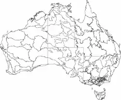
W wersji siódmej IBRA dzieli obszar lądowy Australii na 89 bioregionów wyróżnionych ze względu na klimat, geologię, rzeźbę terenu, rodzimą roślinność i skład gatunkowy. Regiony te podzielono następnie na 419 podregionów (ang. subregions), które są jednostkami bardziej lokalnymi i jednolitymi geomorfologicznie[1].
| A B C D E F G H I J K L M N O P Q R S T V W Y |
A
| Regiony i podregiony (subregions) według IBRA7 | ||||
|---|---|---|---|---|
| Region / podregion IBRA | Kod IBRA[2][3] | Powierzchnia (ha)[2][3] | Jedn. adm.[a] | Zasięg na mapie |
| Arnhem Coast | ARC | 3 335 669 | TP | 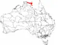 |
| Murgenella | ARC01 | 113 180 | ||
| Maningrida | ARC02 | 1 741 376 | ||
| Nhulunbuy | ARC03 | 1 159 659 | ||
| Groote | ARC04 | 268 735 | ||
| Wessels | ARC05 | 52 720 | ||
| Arnhem Plateau | ARP | 2 306 023 | TP | 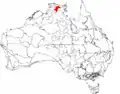 |
| Alligator | ARP01 | 1 038 621 | ||
| Mainoru | ARP02 | 1 267 401 | ||
| Alpy Australijskie | AUA | 1 232 981 | NPW, Wi | 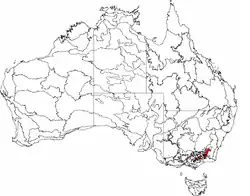 |
| Snowy Mountains | AUA01 | 713 114 | ||
| Victorian Alps | AUA02 | 519 866 | ||
| Avon Wheatbelt | AVW | 9 517 104 | AZ | 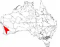 |
| Merredin | AVW01 | 6 524 175 | ||
| Katanning | AVW02 | 2 992 929 | ||
B
| Regiony i podregiony (subregions) według IBRA7 | ||||
|---|---|---|---|---|
| Region / podregion IBRA | Kod IBRA[2][3] | Powierzchnia (ha)[2][3] | Jedn. adm.[a] | Zasięg na mapie |
| Ben Lomond | BEL | 657 500 | Tas | 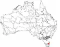 |
| Ben Lomond | BEL01 | |||
| Brigalow Belt North | BBN | 33 790 510 | Qld | 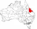 |
| Townsville Plains | BBN01 | 763 495 | ||
| Bogie River Hills | BBN02 | 1 054 392 | ||
| Cape River Hills | BBN03 | 747 393 | ||
| Beucazon Hills | BBN04 | 95 821 | ||
| Wyarra Hills | BBN05 | 397 935 | ||
| Northern Bowen Basin | BBN06 | 1 316 957 | ||
| Belyando Downs | BBN07 | 1 772 127 | ||
| Upper Belyando Floodout | BBN08 | 466 275 | ||
| Anakie Inlier | BBN09 | 382 284 | ||
| Basalt Downs | BBN10 | 1 274 731 | ||
| Isaac-Comet Downs | BBN11 | 2 693 397 | ||
| Nebo-Connors Ranges | BBN12 | 449 269 | ||
| South Drummond Basin | BBN13 | 1 009 244 | ||
| Marlborough Plains | BBN14 | 1 250 611 | ||
| Brigalow Belt South | BBS | 27 219 776 | Qld, NPW | 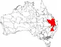 |
| Claude River Downs | BBS01 | 1 026 214 | ||
| Woorabinda | BBS02 | 749 785 | ||
| Boomer Range | BBS03 | 220 541 | ||
| Mount Morgan Ranges | BBS04 | 1 275 970 | ||
| Callide Creek Downs | BBS05 | 30 133 | ||
| Arcadia | BBS06 | 715 288 | ||
| Dawson River Downs | BBS07 | 982 807 | ||
| Banana-Auburn Ranges | BBS08 | 1 547 555 | ||
| Buckland Basalts | BBS09 | 281 306 | ||
| Carnarvon Ranges | BBS10 | 2 263 686 | ||
| Taroom Downs | BBS11 | 652 005 | ||
| Southern Downs | BBS12 | 4 264 666 | ||
| Barakula | BBS13 | 1 301 712 | ||
| Dulacca Downs | BBS14 | 162 442 | ||
| Weribone High | BBS15 | 966 510 | ||
| Tara Downs | BBS16 | 511 339 | ||
| Eastern Darling Downs | BBS17 | 1 697 945 | ||
| Inglewood Sandstones | BBS18 | 1 219 008 | ||
| Moonie-Commoron Floodout | BBS19 | 750 661 | ||
| Moonie-Barwon Interfluve | BBS20 | 765 231 | ||
| Northern Basalts | BBS21 | 624 671 | ||
| Northern Outwash | BBS22 | 700 241 | ||
| Pilliga Outwash | BBS23 | 535 392 | ||
| Pilliga | BBS24 | 1 732 137 | ||
| Liverpool Plains | BBS25 | 941 752 | ||
| Liverpool Range | BBS26 | 521 960 | ||
| Talbragar Valley | BBS27 | 203 894 | ||
| Narrandool | BBS28 | 303 754 | ||
| Broken Hill Complex | BHC | 5635422 | AP, NPW | 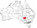 |
| Barrier Range | BHC01 | 1 802 996 | ||
| Mootwingee Downs | BHC02 | 630 694 | ||
| Scopes Range | BHC03 | 260 806 | ||
| Barrier Range Outwash | BHC04 | 1 954 973 | ||
| Bimbowrie | BHC05 | 279 258 | ||
| Curnamona | BHC06 | 706 696 | ||
| Burt Plain | BRT | 7 379 719 | NT | 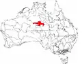 |
| Yuendumu | BRT01 | 2 931 061 | ||
| Atartinga | BRT02 | 3 531 111 | ||
| Mount Chapple | BRT03 | 390 981 | ||
| Dulcie | BRT04 | 526 567 | ||
C
| Regiony i podregiony (subregions) według IBRA7 | ||||
|---|---|---|---|---|
| Region / podregion IBRA | Kod IBRA[2][3] | Powierzchnia (ha)[2][3] | Jedn. adm.[a] | Zasięg na mapie |
| Cape York Peninsula | CYP | 12 256 457 | Qld | 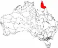 |
| Coen – Yambo Inlier | CYP01 | 2 312 126 | ||
| Starke Coastal Lowlands | CYP02 | 512 498 | ||
| Cape York – Torres Strait | CYP03 | 94 367 | ||
| Jardine – Pascoe Sandstones | CYP04 | 1 444 223 | ||
| Battle Camp Sandstones | CYP05 | 504 409 | ||
| Laura Lowlands | CYP06 | 1 791 228 | ||
| Weipa Plateau | CYP07 | 2 848 753 | ||
| (Northern) Holroyd Plain | CYP08 | 2 464 074 | ||
| Coastal Plains | CYP09 | 284 780 | ||
| Carnarvon | CAR | 8 430 172 | AZ | 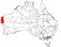 |
| Cape Range | CAR01 | 2 380 498 | ||
| Wooramel | CAR02 | 6 049 674 | ||
| Central Arnhem | CEA | 3 462 433 | NT | 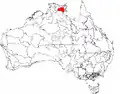 |
| Wilton | CEA01 | 3 137 973 | ||
| Parson | CEA02 | 324 460 | ||
| Central Kimberley | CEK | 7675587 | AZ | 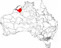 |
| Pentecost | CEK01 | 4 397 260 | ||
| Hart | CEK02 | 2 324 667 | ||
| Mount Eliza (Kimberley) | CEK03 | 953 661 | ||
| Central Mackay Coast | CMC | 1 464 208 | Qld | 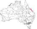 |
| Whitsunday | CMC01 | 89 179 | ||
| Proserpine – Sarina Lowlands | CMC02 | 466 498 | ||
| Clarke – Connors Ranges | CMC03 | 631 985 | ||
| Byfield | CMC04 | 127 697 | ||
| Manifold | CMC05 | 67 885 | ||
| Debella | CMC06 | 80964 | ||
| Central Ranges | CER | 10 164 044 | AZ, TP, AP | 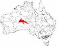 |
| Mann-Musgrave Block | CER01 | 9 214 685 | ||
| Wataru | CER02 | 423 360 | ||
| Everard Block | CER03 | 525 998 | ||
| Channel Country | CHC | 30 409 437 | TP, Qld, NPW, AP | 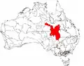 |
| Toko Plains | CHC01 | 2 825 712 | ||
| Sturt Stony Desert | CHC02 | 8 945 360 | ||
| Goneaway Tablelands | CHC03 | 5 182 219 | ||
| Diamantina-Eyre | CHC04 | 1 456 544 | ||
| Cooper-Diamantina Plains | CHC05 | 4 136 121 | ||
| Coongie | CHC06 | 1 736 594 | ||
| Lake Pure | CHC07 | 1 204 027 | ||
| Noccundra Slopes | CHC08 | 1 798 759 | ||
| Tibooburra Downs | CHC09 | |||
| Core Ranges | CHC10 | 139 224 | ||
| Bulloo | CHC11 | 1 077 480 | ||
| Bulloo Dunefields | CHC12 | 1 326 712 | ||
| Central Depression | CHC13 | 580 685 | ||
| Cobar Peneplain | COP | 7 385 346 | NPW | 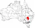 |
| Boorindal Plains | COP1 | 400 236 | ||
| Barnato Downs | COP2 | 1 773 542 | ||
| Canbelego Downs | COP3 | 2 001 425 | ||
| Nymagee | COP4 | 2 070 061 | ||
| Lachlan Plains | COP5 | 1 140 082 | ||
| Coolgardie | COO | 129 122 09 | AZ | 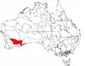 |
| Mardabilla | COO1 | 1 843 125 | ||
| Southern Cross | COO2 | 6 010 838 | ||
| Eastern Goldfields | COO3 | 5 058 246 | ||
| Coral Sea | COS | 17 167 | ||
D
| Regiony i podregiony (subregions) według IBRA7 | ||||
|---|---|---|---|---|
| Region / podregion IBRA | Kod IBRA[2][3] | Powierzchnia (ha)[2][3] | Jedn. adm.[a] | Zasięg na mapie |
| Daly Basin | DAB | 2 092 229 | NT | 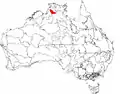 |
| Daly Basin | DAB01 | |||
| Dampierland | DAL | 8 360 871 | AZ | 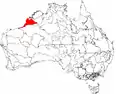 |
| Fitzroy Trough | DAL01 | 3 432 084 | ||
| Pindanland | DAL02 | 4 928 787 | ||
| Darling Riverine Plains | DRP | 10 699 769 | Qld, NPW | 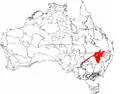 |
| Culgoa-Bokhara | DRP01 | 1 354 799 | ||
| Warrambool-Moonie | DRP02 | 1 151 637 | ||
| Castlereagh-Barwon | DRP03 | 4 500 355 | ||
| Bogan-Macquarie | DRP04 | 1 999 951 | ||
| Louth Plains | DRP05 | 276 573 | ||
| Wilcannia Plains | DRP06 | 504 562 | ||
| Menindee | DRP07 | 653 935 | ||
| Great Darling Anabranch | DRP08 | 147 138 | ||
| Pooncarie-Darling | DRP09 | 110 819 | ||
| Darwin Coastal | DAC | 2 843 199 | NT | 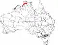 |
| Darwin Coastal | DAC01 | |||
| Davenport Murchison Ranges | DMR | 5 805 108 | NT | 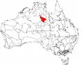 |
| Ashburton Range | DMR01 | 1 218 621 | ||
| Davenport | DMR02 | 1 589 590 | ||
| Barkly | DMR03 | 2 996 897 | ||
| Desert Uplands | DEU | 6 941 095 | Qld | 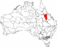 |
| Prairie-Torrens Creeks Alluvials | DEU01 | 1 580 384 | ||
| Alice Tableland | DEU02 | 2 866 760 | ||
| Cape-Campaspe Plains | DEU03 | 1 007 026 | ||
| Jericho | DEU04 | 1 486 926 | ||
E
| Regiony i podregiony (subregions) według IBRA7 | ||||
|---|---|---|---|---|
| Region / podregion IBRA | Kod IBRA[2][3] | Powierzchnia (ha)[2][3] | Jedn. adm.[a] | Zasięg na mapie |
| Einasleigh Uplands | EIU | 11 625 726 | Qld | 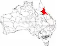 |
| Georgetown – Croydon | EIU01 | 1 041 407 | ||
| Kidston | EIU02 | 2 929 528 | ||
| Hodgkinson Basin | EIU03 | 1 607 221 | ||
| Broken River | EIU04 | 3 309 590 | ||
| Undara – Toomba Basalts | EIU05 | 2 076 208 | ||
| Herberton – Wairuna | EIU06 | 661 771 | ||
| Esperance Plains | ESP | 2 921 327 | AZ | 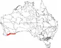 |
| Fitzgerald | ESP01 | 1 577 938 | ||
| Recherche | ESP02 | 1 343 390 | ||
| Eyre Yorke Block | EYB | 6 120 409 | AP | 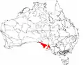 |
| Southern Yorke | EYB01 | 438 470 | ||
| St Vincent | EYB02 | 1 093 789 | ||
| Eyre Hills | EYB03 | 1172576 | ||
| Talia | EYB04 | 1 096 175 | ||
| Eyre Mallee | EYB05 | 2 319 398 | ||
F
| Regiony i podregiony (subregions) według IBRA7 | ||||
|---|---|---|---|---|
| Region / podregion IBRA | Kod IBRA[2][3] | Powierzchnia (ha)[2][3] | Jedn. adm.[a] | Zasięg na mapie |
| Finke | FIN | 7 267 416 | TP, AP | 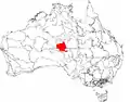 |
| Henbury | FIN01 | 2 257 063 | ||
| Finke River | FIN02 | 1 601 516 | ||
| Tieyon | FIN03 | 2 505 610 | ||
| Pedirka | FIN04 | 903 228 | ||
| Flinders Lofty Block | FLB | 6 615 765 | AP, NPW | 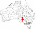 |
| Mount Lofty Ranges | FLB01 | 300 580 | ||
| Broughton | FLB02 | 1 032 918 | ||
| Olary Spur | FLB02 | 1 745 479 | ||
| Southern Flinders | FLB04 | 728 317 | ||
| Northern Flinders | FLB05 | 1 846 804 | ||
| Central Flinders | FLB06 | 961 667 | ||
| Furneaux | FUR | 537 543 | AP, Wi | |
| Wilsons Promontory | FUR01 | 41 144 | ||
| Flinders | FUR02 | 496 398 | ||
G
| Regiony i podregiony (subregions) według IBRA7 | ||||
|---|---|---|---|---|
| Region / podregion IBRA | Kod IBRA[2][3] | Powierzchnia (ha)[2][3] | Jedn. adm.[a] | Zasięg na mapie |
| Gascoyne | GAS | 18 075 257 | AZ | 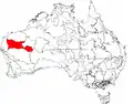 |
| Ashburton | GAS01 | 3 687 030 | ||
| Carnegie | GAS02 | 4 718 656 | ||
| Augustus | GAS03 | 9 669 571 | ||
| Gawler | GAW | 12 002 883 | AP | 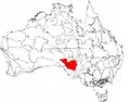 |
| Myall Plains | GAW01 | 1 088 767 | ||
| Gawler Volcanics | GAW02 | 1 556 182 | ||
| Gawler Lakes | GAW03 | 2 049 193 | ||
| Arcoona Plateau | GAW04 | 1 089 865 | ||
| Kingoonya | GAW05 | 1 922 414 | ||
| Torrens | GAW06 | 1 439 093 | ||
| Roxby | GAW07 | 1 409 305 | ||
| Commonwealth Hill | GAW08 | 1 448 062 | ||
| Geraldton Sandplains | GES | 3 142 149 | AZ | 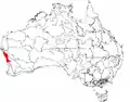 |
| Geraldton Hills | GES01 | 1 969 997 | ||
| Leseur Sandplain | GES02 | 1 172 152 | ||
| Gibson Desert | GID | 15 628 918 | AZ | 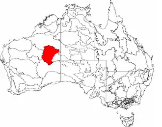 |
| Lateritic Plain | GID01 | 12 714 805 | ||
| Dune Field | GID02 | 2 914 114 | ||
| Great Sandy Desert | GSD | 39 486 135 | NT / AZ | 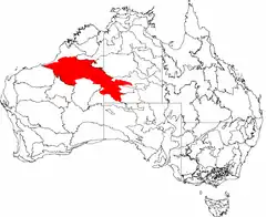 |
| McLarty | GSD01 | 12316754 | ||
| Mackay | GSD02 | 25 698 395 | ||
| Ehrenberg | GSD03 | 375 668 | ||
| Amedeus | GSD04 | 722 845 | ||
| Lake Bennett | GSD05 | 289 541 | ||
| Lake Lewis | GSD06 | 82 932 | ||
| Great Victoria Desert | GVD | 42 246 564 | AP, AZ |  |
| Shield | GVD01 | 4 741 854 | ||
| Central | GVD02 | 12 590 867 | ||
| Maralinga | GVD03 | 11 460 762 | ||
| Kintore | GVD04 | 4 961 542 | ||
| Tallaringa | GVD05 | 3 663 149 | ||
| Yellabinna | GVD06 | 4 828 389 | ||
| Gulf Coastal | GUC | 2 711 718 | TP | 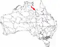 |
| Limmen | GUC01 | 12 714 805 | ||
| Pellews | GUC02 | 2 914 114 | ||
| Gulf Fall and Upland | GFU | 11 847 909 | TP, Qld | 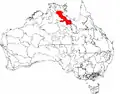 |
| McArthur | GFU01 | 9 330 938 | ||
| Nicholson | GFU02 | 251 6971 | ||
| Gulf Plains | GUP | 22 041 825 | TP, Qld | 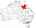 |
| Karumba Plains | GUP01 | 1 057 366 | ||
| Armraynald Plains | GUP02 | 1 589 437 | ||
| Woondoola Plains | GUP03 | 2 375 110 | ||
| Mitchell-Gilbert Fans | GUP04 | 5 262 816 | ||
| Claraville Plains | GUP05 | 3 738 013 | ||
| Holroyd Plain-Red Plateau | GUP06 | 2 208 468 | ||
| Doomadgee Plains | GUP07 | 1 831 823 | ||
| Donors Plateau | GUP08 | 2 449 964 | ||
| Gilberton Plateau | GUP09 | 1 403 937 | ||
| Wellesley Islands | GUP10 | 124 893 | ||
H
| Regiony i podregiony (subregions) według IBRA7 | ||||
|---|---|---|---|---|
| Region / podregion IBRA | Kod IBRA[2][3] | Powierzchnia (ha)[2][3] | Jedn. adm.[a] | Zasięg na mapie |
| Hampton | HAM | 1 088 198 | AZ | 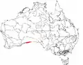 |
| Hampton | HAM01 | |||
I
| Regiony i podregiony (subregions) według IBRA7 | ||||
|---|---|---|---|---|
| Region / podregion IBRA | Kod IBRA[2][3] | Powierzchnia (ha)[2][3] | Jedn. adm.[a] | Zasięg na mapie |
| Indian Tropical Islands | ITI | 27 329 | ||
| Christmas Island | ITI01 | 13 664 | ||
| Cocos Islands | ITI02 | 1 463 | ||
| Timor Sea Coral Islands | ITI03 | 12 203 | ||
J
| Regiony i podregiony (subregions) według IBRA7 | ||||
|---|---|---|---|---|
| Region / podregion IBRA | Kod IBRA[2][3] | Powierzchnia (ha)[2][3] | Jedn. adm.[a] | Zasięg na mapie |
| Jarrah Forest | JAF | 4 509 074 | AZ | 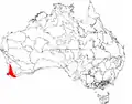 |
| Northern Jarrah Forest | JAF01 | 1 898 799 | ||
| Southern Jarrah Forest | JAF02 | 2 610 275 | ||
K
| Regiony i podregiony (subregions) według IBRA7 | ||||
|---|---|---|---|---|
| Region / podregion IBRA | Kod IBRA[2][3] | Powierzchnia (ha)[2][3] | Jedn. adm.[a] | Zasięg na mapie |
| Kanmantoo | KAN | 812 415 | SA | 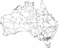 |
| Kangaroo Island | KAN01 | 441 685 | ||
| Fleurieu | KAN02 | 370 730 | ||
| King | KIN | 425567 | Tas | 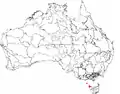 |
| King | KIN01 | |||
L
| Regiony i podregiony (subregions) według IBRA7 | ||||
|---|---|---|---|---|
| Region / podregion IBRA | Kod IBRA[2][3] | Powierzchnia (ha)[2][3] | Jedn. adm.[a] | Zasięg na mapie |
| Little Sandy Desert | LSD | 11 089 857 | AZ | 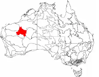 |
| Rudall | LSD01 | 991 277 | ||
| Trainor | LSD02 | 10 098 580 | ||
M
| Regiony i podregiony (subregions) według IBRA7 | ||||
|---|---|---|---|---|
| Region / podregion IBRA | Kod IBRA[2][3] | Powierzchnia (ha)[2][3] | Jedn. adm.[a] | Zasięg na mapie |
| MacDonnell Ranges | MAC | 3 929 444 | TP | 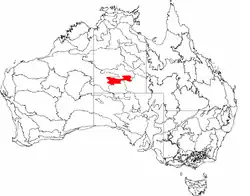 |
| McDonnell | MAC01 | 1 483 959 | ||
| Watarrka | MAC02 | 1092782 | ||
| Hartz Range | MAC03 | 1352702 | ||
| Mallee | MAL | 7 397 559 | AZ | 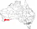 |
| Eastern Mallee | MAL01 | 3 415 839 | ||
| Western Mallee | MAL02 | 3 981 720 | ||
| Mitchell Grass Downs | MGD | 33 468 761 | TP, Qld | 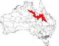 |
| Sylvester | MGD01 | 1 153 283 | ||
| Barkly Tableland | MGD02 | 9 479 612 | ||
| Georgina Limestone | MGD03 | 2 292 026 | ||
| Southwestern Downs | MGD04 | 3 715 454 | ||
| Kynuna Plateau | MGD05 | 2 293 311 | ||
| Northern Downs | MGD06 | 435 263 | ||
| Central Downs | MGD07 | 9 378 817 | ||
| Southern Wooded Downs | MGD08 | 4 720 995 | ||
| Mount Isa Inlier | MII | 6 778 263 | Qld | 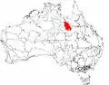 |
| Southwestern Plateaus and Floodouts | MII01 | 1 333 519 | ||
| Thorntonia | MII02 | 802 892 | ||
| Mount Isa | MII03 | 4641851 | ||
| Mulga Lands | MUL | 25188333 | NPW, Qld | 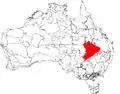 |
| West Balonne Plains | MUL01 | 1 991 194 | ||
| Eastern Mulga Plains | MUL02 | 1 563 269 | ||
| Nebine Plains, Block Range | MUL03 | 1 898 731 | ||
| North Eastern Plains | MUL04 | 660 369 | ||
| Warrego Plains | MUL05 | 2 492 085 | ||
| Langlo Plains | MUL06 | 1 290 484 | ||
| Cuttaburra-Paroo | MUL07 | 1 703 985 | ||
| West Warrego | MUL08 | 4 790 087 | ||
| Northern Uplands | MUL09 | 1 147 549 | ||
| West Bulloo | MUL10 | 2 852 104 | ||
| Urisino Sandplains | MUL11 | 2 007 350 | ||
| Warrego Sands | MUL12 | 479 471 | ||
| Kerribree Basin | MUL13 | 399 576 | ||
| White Cliffs Plateau | MUL14 | 1 074 309 | ||
| Paroo Overflow | MUL15 | 301 217 | ||
| Paroo-Darling Sands | MUL16 | 536 556 | ||
| Murchison | MUR | 28 120 554 | AZ | 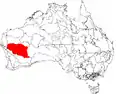 |
| Eastern Murchison | MUR01 | 21 135 040 | ||
| Western Murchison | MUR02 | 6 985 514 | ||
| Murray Darling Depression | MDD | 19 958 349 | NPW, AP, Wik | 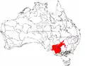 |
| South Olary Plain | MDD01 | 5 439 224 | ||
| Murray Mallee | MDD02 | 5 037 583 | ||
| Murray Lakes and Coorong | MDD03 | 249 191 | ||
| Lowan Mallee | MDD04 | 2 391 719 | ||
| Wimmera | MDD05 | 2 145 380 | ||
| Darling Depression | MDD06 | 3 662 438 | ||
| Braemer | MDD07 | 1 032 815 | ||
N
| Regiony i podregiony (subregions) według IBRA7 | ||||
|---|---|---|---|---|
| Region / podregion IBRA | Kod IBRA[2][3] | Powierzchnia (ha)[2][3] | Jedn. adm.[a] | Zasięg na mapie |
| Nandewar | NAN | 2 701 977 | NPW, Qld | 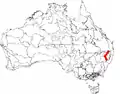 |
| Nandewar Northern Complex | NAN01 | 962 254 | ||
| Inverell Basalts | NAN02 | 230 854 | ||
| Kaputar | NAN03 | 78 307 | ||
| Peel | NAN04 | 1 430 562 | ||
| Naracoorte Coastal Plain | NCP | 2 458 215 | SA / Vic |  |
| Bridgewater | NCP01 | 463 723 | ||
| Glenelg Plain | NCP02 | 554 775 | ||
| Lucindale | NCP03 | 731 656 | ||
| Tintinara | NCP04 | 708 061 | ||
| New England Tablelands | NET | 3 002 213 | NPW | 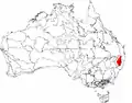 |
| Bundarra Downs | NET01 | 151 867 | ||
| Beardy River Hills | NET02 | 24 625 | ||
| Walcha Plateau | NET03 | 473 825 | ||
| Armidale Plateau | NET04 | 290 577 | ||
| Wongwibinda Plateau | NET05 | 106 929 | ||
| Deepwater Downs | NET06 | 97 773 | ||
| Glenn Innes-Guyra Basalts | NET07 | 277 299 | ||
| Ebor Basalts | NET08 | 35 709 | ||
| Moredun Volcanics | NET09 | 117 461 | ||
| Severn River Volcanics | NET10 | 150 795 | ||
| Northeast Forest Lands | NET11 | 206 492 | ||
| Tenterfield Plateau | NET12 | 139 242 | ||
| Yarrowyck-Kentucky Downs | NET13 | 65 135 | ||
| Binghi Plateau | NET14 | 64 555 | ||
| Stanthorpe Plateau | NET15 | 267 999 | ||
| Eastern Nandewars | NET16 | 319 096 | ||
| Tingha Plateau | NET17 | 78 461 | ||
| Nightcap | NET18 | 113 767 | ||
| Round Mountain | NET19 | 20 606 | ||
| Northern Kimberley | NOK | 8 420 100 | AZ | 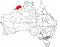 |
| Mitchell | NOK01 | 5 970 915 | ||
| Berkeley | NOK02 | 2 449 185 | ||
| NSW North Coast | NNC | 3 996 591 | NPW | 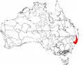 |
| Washpool | NNC01 | 59 377 | ||
| Cataract | NNC02 | 121 338 | ||
| Dalmorton | NNC03 | 316 458 | ||
| Chaelundi | NNC04 | 188 279 | ||
| Yuraygir | NNC05 | 45 815 | ||
| Coffs Coast and Escarpment | NNC06 | 308 115 | ||
| Macleay Hastings | NNC07 | 729 170 | ||
| Carrai Plateau | NNC08 | 20 100 | ||
| Macleay Gorges | NNC09 | 153 349 | ||
| Upper Manning | NNC10 | 83 181 | ||
| Comboyne Plateau | NNC11 | 123 315 | ||
| Mummel Escarpment | NNC12 | 400 916 | ||
| Barrington | NNC13 | 110 903 | ||
| Tomalla | NNC14 | 227 615 | ||
| Ellerston | NNC15 | 113 183 | ||
| Upper Hunter | NNC16 | 232 750 | ||
| Karuah Manning | NNC17 | 602 423 | ||
| Rocky River Gorge | NNC18 | 86 829 | ||
| Guy Fawkes | NNC19 | 73 477 | ||
| NSW South Western Slopes | NSS | 8 681 126 | NPW, Wi | 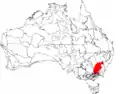 |
| Inland Slopes | NSS01 | 4 640 857 | ||
| Lower Slopes | NSS02 | 3 938 809 | ||
| Capertee Valley | NSS03 | 101 460 | ||
| Nullarbor | NUL | 19 722 774 | AP, AZ |  |
| Carlisle | NUL01 | 5 788 547 | ||
| Nullarbor Plain | NUL02 | 12 785 260 | ||
| Yalata | NUL03 | 1 148 966 | ||
O
| Regiony i podregiony (subregions) według IBRA7 | ||||
|---|---|---|---|---|
| Region / podregion IBRA | Kod IBRA[2][3] | Powierzchnia (ha)[2][3] | Jedn. adm.[a] | Zasięg na mapie |
| Ord Victoria Plain | OVP | 12 540 703 | TP, AZ | 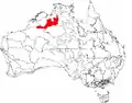 |
| Purnululu | OVP01 | 3 233 873 | ||
| South Kimberley Interzone | OVP02 | 7 728 296 | ||
| Gregory | OVP03 | 74 982 | ||
| Camfield | OVP04 | 828 712 | ||
P
| Regiony i podregiony (subregions) według IBRA7 | ||||
|---|---|---|---|---|
| Region / podregion IBRA | Kod IBRA[2][3] | Powierzchnia (ha)[2][3] | Jedn. adm.[a] | Zasięg na mapie |
| Pacific Subtropical Islands | PSI | 5 817 | ||
| Lord Howe Island | PSI01 | 1 909 | ||
| Norfolk Island | PSI02 | 3 908 | ||
| Pine Creek | PCK | 2 851 777 | TP | 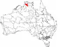 |
| Pine Creek | PCK01 | |||
| Pilbara | PIL | 17823126 | AZ | 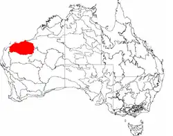 |
| Chichester | PIL01 | 8 374 728 | ||
| Fortescue | PIL02 | 1 951 435 | ||
| Hamersley | PIL03 | 5 634 727 | ||
| Roebourne | PIL04 | 1 862 236 | ||
R
| Regiony i podregiony (subregions) według IBRA7 | ||||
|---|---|---|---|---|
| Region / podregion IBRA | Kod IBRA[2][3] | Powierzchnia (ha)[2][3] | Jedn. adm.[a] | Zasięg na mapie |
| Riverina | RIV | 9 704 469 | NPW, AP, Wi | 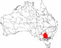 |
| Lachlan | RIV01 | 2 377 523 | ||
| Murrumbidgee | RIV02 | 2 946 813 | ||
| Murray Fans | RIV03 | 1 952 238 | ||
| Victorian Riverina | RIV04 | 1 890 627 | ||
| Robinvale Plains | RIV05 | 162 003 | ||
| Murray Scroll Belt | RIV06 | 375 266 | ||
S
| Regiony i podregiony (subregions) według IBRA7 | ||||
|---|---|---|---|---|
| Region / podregion IBRA | Kod IBRA[2][3] | Powierzchnia (ha)[2][3] | Jedn. adm.[a] | Zasięg na mapie |
| Simpson Strzelecki Dunefields | SSD | 27 984 283 | NPW, TP, Qld, AP | 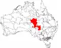 |
| Andado | SSD01 | 1 355 195 | ||
| Simpson Desert | SSD02 | 12 962 073 | ||
| Dieri | SSD03 | 5 152 029 | ||
| Wariner | SSD04 | 1 032 165 | ||
| Strzelecki Desert | SSD05 | 7 482 821 | ||
| South East Coastal Plain | SCP | 1749237 | Vic | 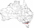 |
| Gippsland Plain | SCP01 | 1 246 995 | ||
| Otway Plain | SCP02 | 237799 | ||
| Warrnambool Plain | SCP03 | 264 443 | ||
| South East Corner | SEC | 2 532 053 | NPW, Wi | 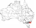 |
| East Gippsland Lowlands | SEC01 | 623 515 | ||
| South East Coastal Ranges | SEC02 | 1 734 517 | ||
| Bateman | SEC03 | 174 020 | ||
| South Eastern Highlands | SEH | 8 375 961 | ATS, NPW, Wi | 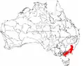 |
| Highlands-Southern Fall | SEH01 | 1 196 334 | ||
| Highlands-Northern Fall | SEH02 | 1 415 806 | ||
| Otway Ranges | SEH03 | 149 857 | ||
| Strzelecki Ranges | SEH04 | 342 045 | ||
| Murrumbateman | SEH06 | 630 454 | ||
| Bungonia | SEH07 | 431 185 | ||
| Kanangra | SEH08 | 131 310 | ||
| Crookwell | SEH09 | 466 523 | ||
| Oberon | SEH10 | 293 164 | ||
| Bathurst | SEH11 | 161 486 | ||
| Orange | SEH12 | 284 172 | ||
| Hill End | SEH13 | 504 377 | ||
| Bondo | SEH14 | 541 990 | ||
| Kybeyan-Gourock | SEH15 | 479 221 | ||
| Monaro | SEH16 | 1 267 543 | ||
| Capertee Uplands | SEH17 | 80 494 | ||
| South East Queensland | SEQ | 7 804 921 | NPW, Qld | 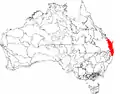 |
| Burnett-Curtis Hills and Ranges | SEQ01 | 962 583 | ||
| Moreton Basin | SEQ02 | 784 969 | ||
| Burringbar-Conondale Ranges | SEQ03 | 630 616 | ||
| Sunshine Coast-Gold Coast Lowlands | SEQ04 | 351 123 | ||
| Brisbane-Barambah Volcanics | SEQ05 | 806 778 | ||
| South Burnett | SEQ06 | 563 866 | ||
| Gympie Block | SEQ07 | 859 020 | ||
| Burnett-Curtis Coastal Lowlands | SEQ08 | 700 181 | ||
| Great Sandy | SEQ09 | 356 502 | ||
| Scenic Rim | SEQ10 | 614 729 | ||
| Woodenbong | SEQ11 | 325 603 | ||
| Clarence Sandstones | SEQ12 | 327 829 | ||
| Clarence Lowlands | SEQ13 | 520 901 | ||
| Southern Volcanic Plain | SVP | 2 440 340 | NPW, Wi | |
| Victorian Volcanic Plain | SVP01 | 2 356 147 | ||
| Mount Gambier | SVP02 | 84 194 | ||
| Stony Plains | STP | 13166372 | SA | 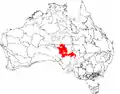 |
| Breakaways | STP01 | 2 444 385 | ||
| Oodnadatta | STP02 | 2 593 717 | ||
| Murnpeowie | STP03 | 2 910 385 | ||
| Peake-Dennison Inlier | STP04 | 158 623 | ||
| Macumba | STP05 | 693,282 | ||
| Witjira | STP06 | 1 677 111 | ||
| Baltana | STP07 | 2 688 870 | ||
| Sturt Plateau | STU | 9 857 531 | TP | 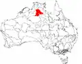 |
| Renehan | STU01 | 1 938 959 | ||
| Newcastle | STU02 | 4 333 836 | ||
| Birdum | STU03 | 3584,736 | ||
| Subantarctic Islands | SAI | 49 164 | NPW, Wi | |
| Heard and McDonald Islands | SAI01 | 36 764 | ||
| Macquarie Island | SAI02 | 12 400 | ||
| Swan Coastal Plain | SWA | 1 525 798 | AZ | 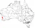 |
| Dandarragan Plateau | SWA01 | 383465 | ||
| Perth | SWA02 | 1142334 | ||
| Sydney Basin | SYB | 3629597 | NPW | 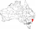 |
| Kerrabee | SYB01 | 437 384 | ||
| Hunter | SYB02 | 461 515 | ||
| Wollemi | SYB04 | 687 622 | ||
| Yengo | SYB05 | 461 327 | ||
| Wyong | SYB06 | 211 494 | ||
| Pittwater | SYB07 | 148 389 | ||
| Cumberland | SYB08 | 275 693 | ||
| Burragorang | SYB09 | 257 572 | ||
| Sydney Cataract | SYB10 | 153 839 | ||
| Moss Vale | SYB11 | 96 903 | ||
| Illawarra | SYB12 | 122 752 | ||
| Ettrema | SYB13 | 179 126 | ||
| Jervis | SYB14 | 135 981 | ||
T
| Regiony i podregiony (subregions) według IBRA7 | ||||
|---|---|---|---|---|
| Region / podregion IBRA | Kod IBRA[2][3] | Powierzchnia (ha)[2][3] | Jedn. adm.[a] | Zasięg na mapie |
| Tanami | TAN | 25 997 277 | TP, AZ | 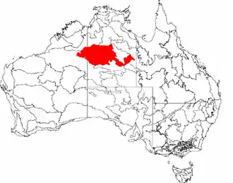 |
| Tanami Desert | TAN01 | 20 769 151 | ||
| Wycliffe | TAN02 | 1 600 893 | ||
| Sandover | TAN03 | 3 627 233 | ||
| Tasmanian Central Highlands | TCH | 767 849 | Tas | 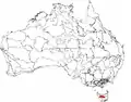 |
| Central Highlands | TCH01 | |||
| Tasmanian Northern Midlands | TNM | 415 445 | Tas | 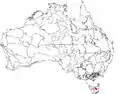 |
| Northern Midlands | TNM01 | |||
| Tasmanian Northern Slopes | TNS | 623 103 | Tas |  |
| Northern Slopes | TNS01 | |||
| Tasmanian South East | TSE | 1 131 822 | Tas | 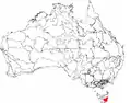 |
| South East | TSE01 | |||
| Tasmanian Southern Ranges | TSR | 757 228 | Tas | 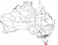 |
| Southern Ranges | TSR01 | |||
| Tasmanian West | TWE | 1 565 077 | Tas | 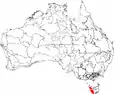 |
| West | TWE01 | |||
| Tiwi Cobourg | TIW | 1 010 580 | TP | 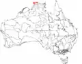 |
| Tiwi | TIW01 | 748 927 | ||
| Coburg | TIW02 | 261 652 | ||
V
| Regiony i podregiony (subregions) według IBRA7 | ||||
|---|---|---|---|---|
| Region / podregion IBRA | Kod IBRA[2][3] | Powierzchnia (ha)[2][3] | Jedn. adm.[a] | Zasięg na mapie |
| Victoria Bonaparte | VIB | 7 301 242 | TP, AZ | 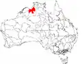 |
| Keep | VIB01 | 6 441 592 | ||
| Hermit Creek | VIB02 | 170 646 | ||
| Angalarri | VIB03 | 689 004 | ||
| Victorian Midlands | VIM | 3469789 | Wi | 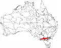 |
| Goldfields | VIM01 | 1 326 133 | ||
| Central Victorian Uplands | VIM02 | 1 217 922 | ||
| Greater Grampians | VIM03 | 237 416 | ||
| Dundas Tablelands | VIM04 | 688 318 | ||
W
| Regiony i podregiony (subregions) według IBRA7 | ||||
|---|---|---|---|---|
| Region / podregion IBRA | Kod IBRA[2][3] | Powierzchnia (ha)[2][3] | Jedn. adm.[a] | Zasięg na mapie |
| Warren | WAR | 844 771 | AZ | 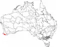 |
| Warren | WAR01 | |||
| Wet Tropics | WET | 1 989 107 | Qld | 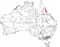 |
| Herbert | WET01 | 220 920 | ||
| Tully | WET02 | 162 958 | ||
| Innisfail | WET03 | 195 200 | ||
| Atherton | WET04 | 177 037 | ||
| Paluma-Seaview | WET05 | 233 751 | ||
| Kirrama-Hinchinbrook | WET06 | 257 594 | ||
| Bellenden Ker-Lamb | WET07 | 271 062 | ||
| Macalister | WET08 | 112 652 | ||
| Daintree-Bloomfield | WET09 | 357 932 | ||
Y
| Regiony i podregiony (subregions) według IBRA7 | ||||
|---|---|---|---|---|
| Region / podregion IBRA | Kod IBRA[2][3] | Powierzchnia (ha)[2][3] | Jedn. adm.[a] | Zasięg na mapie |
| Yalgoo | YAL | 5 087 577 | AZ | 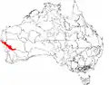 |
| Edel | YAL01 | 1 588 634 | ||
| Tallering | YAL02 | 3 498 943 | ||
Uwagi
- 1 2 3 4 5 6 7 8 9 10 11 12 13 14 15 16 17 18 19 20 21 22 AP – Australia Południowa, ATS – Australijskie Terytorium Stołeczne, AZ – Australia Zachodnia, NPW – Nowa Południowa Walia, Qld – Queensland, Tas – Tasmania, TP – Terytorium Północne, Wi – Wiktoria.
Przypisy
- 1 2 Australian Government’s Department of Sustainability, Environment, Water, Population and Communities: Australia’s bioregions (IBRA). [dostęp 2014-09-01]. [zarchiwizowane z tego adresu (2014-08-07)].
- 1 2 3 4 5 6 7 8 9 10 11 12 13 14 15 16 17 18 19 20 21 22 23 24 25 26 27 28 29 30 31 32 33 34 35 36 37 38 39 40 41 42 43 44 Australian Government’s Department of Sustainability, Environment, Water, Population and Communities: IBRA7 subregions. [dostęp 2014-09-01]. [zarchiwizowane z tego adresu (2014-03-12)].
- 1 2 3 4 5 6 7 8 9 10 11 12 13 14 15 16 17 18 19 20 21 22 23 24 25 26 27 28 29 30 31 32 33 34 35 36 37 38 39 40 41 42 43 44 Australian Government’s Department of Sustainability, Environment, Water, Population and Communities: Interim Biogeographic Regionalisation for Australia (IBRA7) Codes. [dostęp 2014-09-01]. [zarchiwizowane z tego adresu (2014-02-15)].