Cardiff (hrabstwo)
| hrabstwo miejskie | |||
 Cardiff | |||
| |||
| Państwo | |||
|---|---|---|---|
| Księstwo | |||
| Siedziba | |||
| Powierzchnia |
139 km² | ||
| Wysokość |
41 m n.p.m. | ||
| Populacja • liczba ludności |
| ||
Położenie na mapie Walii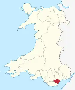 | |||
| Strona internetowa | |||

Cardiff – hrabstwo miejskie w południowej Walii, obejmujące miasto Cardiff i jego najbliższe okolice. W 2011 roku hrabstwo liczyło 346 090 mieszkańców[1][2].
Podział administracyjny
Communities (civil parishes)
- Adamsdown, Butetown, Caerau, Canton, Castle, Cathays, Cyncoed, Ely, Fairwater, Gabalfa, Grangetown, Heath, Lisvane, Llandaff, Llandaff North, Llanishen, Llanrumney, Old St. Mellons, Pentwyn, Pentyrch, Penylan, Pontprennau, Radyr and Morganstown, Rhiwbina, Riverside, Roath, Rumney, Splott, St. Fagans, Tongwynlais, Trowbridge, Whitchurch.
Okręgi wyborcze (wards)
- Adamsdown, Butetown, Caerau, Canton, Cathays, Creigiau/St. Fagans, Cyncoed, Ely, Fairwater, Gabalfa, Grangetown, Heath, Lisvane, Llandaff, Llandaff North, Llanishen, Llanrumney, Pentwyn, Pentyrch, Penylan, Plasnewydd, Pontprennau/Old St. Mellons, Radyr, Rhiwbina, Riverside, Rumney, Splott, Trowbridge, Whitchurch and Tongwynlais[3].
Miejscowości
Miejscowości w Cardiff
Na terenie hrabstwa znajdują się następujące miejscowości[4][5] (w nawiasach liczba ludności w 2011[6]):
- Cardiff (335 145)
- Creigiau (2380)
- Pentyrch (2287)
- St Fagans (282)
Przypisy
- ↑ Area: Cardiff (Local Authority). Neighbourhood Statistics (ONS). [dostęp 2016-10-31]. [zarchiwizowane z tego adresu (2016-10-31)]. (ang.).
- ↑ Cardiff, [w:] Encyclopædia Britannica [dostęp 2016-10-31] (ang.).
- ↑ Caerdydd - Cardiff. Ordnance Survey linked data. [dostęp 2016-10-31]. (ang.).
- ↑ Office for National Statistics: Built-up Area to Local Authority District (December 2011) Lookup in England and Wales. [w:] Open Geography Portal [on-line]. [dostęp 2022-06-05]. (ang.).
- ↑ Office for National Statistics: Built-up Area Sub Divisions (December 2011) Boundaries. [w:] Open Geography Potal [on-line]. [dostęp 2022-06-05]. (ang.).
- ↑ Office for National Statistics: KS101EW - Usual resident population. [w:] 2011 Census [on-line]. Nomis – Official labour market statistics, 2013-02-12. [dostęp 2022-06-05]. (ang.).