Cherwell (dystrykt)
| dystrykt niemetropolitalny | |
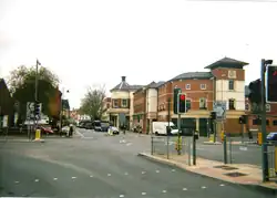 Banbury | |
| Państwo | |
|---|---|
| Kraj | |
| Region | |
| Hrabstwo | |
| Siedziba | |
| Powierzchnia |
588,8 km² |
| Populacja (2011) • liczba ludności |
|
| • gęstość |
240 os./km² |
Położenie na mapie Oxfordshire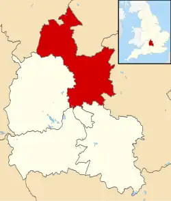 | |
| Strona internetowa | |
Cherwell – dystrykt w hrabstwie Oxfordshire w Anglii (nazwę bierze od rzeki Cherwell).
Miasta
Inne miejscowości
Adderbury, Alkerton, Ambrosden, Ardley, Arncott, Bainton, Balscote, Barford St. John, Barford St. Michael, Begbroke, Blackthorn, Bletchingdon, Bloxham, Bodicote, Bourton, Broughton, Bucknell, Burdrop, Caversfield, Charlton-on-Otmoor, Chesterton, Claydon, Clifton, Cottisford, Cropredy, Deddington, Drayton, Duns Tew, Epwell, Finmere, Fringford, Fritwell, Godington, Gosford, Great Bourton, Hampton Gay, Hampton Poyle, Hardwick (Banbury), Hardwick (Hardwick with Tusmore), Hethe, Hook Norton, Horley, Hornton, Horton-cum-Studley, Islip, Kidlington, Kirtlington, Launton, Lower Heyford, Merton, Middle Aston, Middleton Stoney, Milcombe, Milton, Mixbury, Mollington, Murcott, Newton Purcell, Noke, North Aston, North Newington, Oddington, Piddington, Shelswell, Shenington, Shipton-on-Cherwell, Shutford, Sibford Ferris, Sibford Gower, Somerton, Souldern, South Newington, Steeple Aston, Stoke Lyne, Stratton Audley, Swalcliffe, Tadmarton, Thrupp, Upper Arncott, Upper Heyford, Wardington, Wendlebury, Weston-on-the-Green, Wigginton, Wroxton, Yarnton.