South East England
| Region | |
.jpg) Wybrzeże klifowe w Dover | |
| Państwo | |
|---|---|
| Kraj | |
| Powierzchnia |
19 070 km² |
| Populacja (2021) • liczba ludności |
|
| • gęstość |
487 os./km² |
Położenie na mapie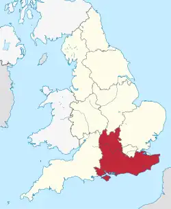 | |
| Strona internetowa | |
South East England (South East) – jeden z dziewięciu regionów Anglii, obejmujący jej południowo-wschodnią część. Zajmuje powierzchnię 19 070 km² (15% terytorium Anglii)[1], w 2021 roku zamieszkany był przez 9 294 800 osób (16% ludności Anglii)[2].
Największe miasta regionu to Southampton (liczba mieszkańców w 2011 r. – 253 651), Portsmouth (238 137), Brighton and Hove (229 700), Reading (218 705), Milton Keynes (171 750), Oksford (159 994), Slough (155 298) i High Wycombe (120 256)[3].
Najwyższym punktem jest Walbury Hill, w hrabstwie Berkshire, o wysokości 297 m n.p.m[4].
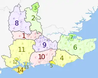
Podział terytorialny
Region South East obejmuje dziewięć hrabstw ceremonialnych. Podzielony jest na 19 jednostek administracyjnych niższego rzędu: 6 hrabstw niemetropolitalnych i 13 jednostek typu unitary authority[5].
Przypisy
- ↑ Census 2011: Usual resident population. Nomis. [dostęp 2023-02-27]. (ang.).
- ↑ Labour Market Profile - South East. Nomis. [dostęp 2023-02-27]. (ang.).
- ↑ KS101EW – Usual resident population. Nomis. [dostęp 2023-02-27]. (ang.).
- ↑ Facts about South East England. Visit South East England. [dostęp 2023-02-27]. (ang.).
- ↑ South East. [w:] Open Data [on-line]. Department for Levelling Up, Housing and Communities. [dostęp 2023-02-27]. (ang.).
![]()