West Midlands (region)
| Region | |
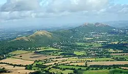 Pasmo wzgórz Malvern Hills | |
| Państwo | |
|---|---|
| Kraj | |
| Powierzchnia |
12 998 km² |
| Populacja (2021) • liczba ludności |
|
| • gęstość |
458 os./km² |
Położenie na mapie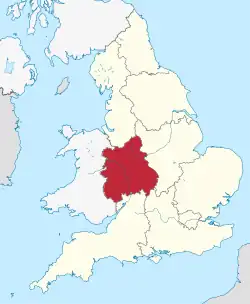 | |
| Strona internetowa | |
West Midlands – jeden z dziewięciu regionów Anglii, obejmujący jej środkowo-zachodnią część – zachodnią część krainy Midlands. Zajmuje powierzchnię 12 998 km² (10% terytorium Anglii)[1], w 2021 roku zamieszkany był przez 5 954 200 osób (11% ludności Anglii)[2].
Największe miasta regionu to Birmingham (liczba mieszkańców w 2011 r. – 1 085 810), Coventry (325 949), Stoke-on-Trent (270 726), Wolverhampton (210 319), Telford (142 723), Solihull (123 187), Sutton Coldfield (109 015) i Worcester (100 153)[3].
Region stanowił okręg wyborczy do Parlamentu Europejskiego.
Geografia
Przez region płynie rzeka Severn. Najwyższym wzniesieniem jest Black Mountain (703 m n.p.m.) w hrabstwie Herefordshire, na granicy walijskiej[4].
Podział terytorialny
Region West Midlands obejmuje sześć hrabstw ceremonialnych. Podzielony jest na 8 jednostek administracyjnych niższego rzędu: 3 hrabstwa niemetropolitalne, 1 metropolitalne i 4 jednostki typu unitary authority[5].
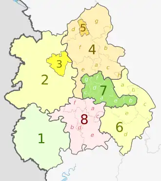
| Nr na mapie | Hrabstwo ceremonialne | Hrabstwo administracyjne (metropolitalne lub niemetropolitalne) | Dystrykt (metropolitalny lub niemetropolitalny) |
|---|---|---|---|
| lub jednostka typu unitary authority | |||
| 1 | Herefordshire | Herefordshire | |
| 2 | Shropshire | Shropshire | |
| 3 | Telford and Wrekin | ||
| 4a | Staffordshire | Staffordshire | Cannock Chase |
| 4b | East Staffordshire | ||
| 4c | Lichfield | ||
| 4d | Newcastle-under-Lyme | ||
| 4e | South Staffordshire | ||
| 4f | Stafford | ||
| 4g | Staffordshire Moorlands | ||
| 4h | Tamworth | ||
| 5 | Stoke-on-Trent | ||
| 6a | Warwickshire | Warwickshire | North Warwickshire |
| 6b | Nuneaton and Bedworth | ||
| 6c | Rugby | ||
| 6d | Stratford-on-Avon | ||
| 6e | Warwick | ||
| 7a | West Midlands | West Midlands | Birmingham |
| 7b | Coventry | ||
| 7c | Dudley | ||
| 7d | Sandwell | ||
| 7e | Solihull | ||
| 7f | Walsall | ||
| 7g | Wolverhampton | ||
| 8a | Worcestershire | Worcestershire | Bromsgrove |
| 8b | Malvern Hills | ||
| 8c | Redditch | ||
| 8d | Worcester | ||
| 8e | Wychavon | ||
| 8f | Wyre Forest | ||
Przypisy
- ↑ Census 2011: Usual resident population. Nomis. [dostęp 2023-03-02]. (ang.).
- ↑ Labour Market Profile - West Midlands. Nomis. [dostęp 2023-03-02]. (ang.).
- ↑ KS101EW - Usual resident population. Nomis. [dostęp 2023-03-02]. (ang.).
- ↑ Richard Gower: The English county tops. Richard Gower. [dostęp 2023-03-02]. (ang.).
- ↑ West Midlands. [w:] Open Data [on-line]. Department for Levelling Up, Housing and Communities. [dostęp 2023-03-02]. (ang.).
![]()