East of England
| Region | |
.jpg) Wiatrak i kanał melioracyjny w Horsey, w krainie The Broads | |
| Państwo | |
|---|---|
| Kraj | |
| Powierzchnia |
19 108 km² |
| Populacja (2021) • liczba ludności |
|
| • gęstość |
332 os./km² |
Położenie na mapie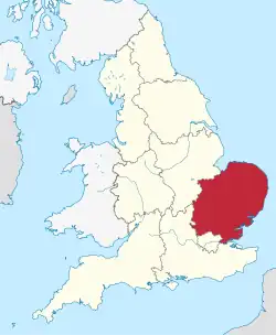 | |
East of England – jeden z dziewięciu regionów Anglii, obejmujący Anglię Wschodnią oraz przyległe hrabstwa. Zajmuje powierzchnię 19 108 km² (15% terytorium Anglii)[1], w 2021 roku zamieszkany był przez 6 348 100 osób (11% ludności Anglii)[2].
Największe miasta regionu to Luton (liczba mieszkańców w 2011 r. – 211 228), Norwich (186 682), Southend-on-Sea (175 547), Peterborough (161 707), Cambridge (145 818), Ipswich (144 957), Watford (131 982), Colchester (119 441), Chelmsford (110 507) i Basildon (107 123)[3].
Podział terytorialny
Region East of England obejmuje sześć hrabstw ceremonialnych. Podzielony jest na 11 jednostek administracyjnych niższego rzędu: 5 hrabstw niemetropolitalnych i 6 jednostek typu unitary authority[4].
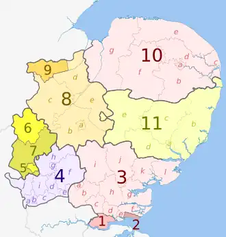
| Nr na mapie | Hrabstwo ceremonialne | Hrabstwo niemetropolitalne | Dystrykt niemetropolitalny |
|---|---|---|---|
| lub jednostka typu unitary authority | |||
| 1 | Essex | Thurrock | |
| 2 | Southend-on-Sea | ||
| 3a | Essex | Harlow | |
| 3b | Epping Forest | ||
| 3c | Brentwood | ||
| 3d | Basildon | ||
| 3e | Castle Point | ||
| 3f | Rochford | ||
| 3g | Maldon | ||
| 3h | Chelmsford | ||
| 3i | Uttlesford | ||
| 3j | Braintree | ||
| 3k | Colchester | ||
| 3l | Tendring | ||
| 4a | Hertfordshire | Hertfordshire | Three Rivers |
| 4b | Watford | ||
| 4c | Hertsmere | ||
| 4d | Welwyn Hatfield | ||
| 4e | Broxbourne | ||
| 4f | East Hertfordshire | ||
| 4g | Stevenage | ||
| 4h | North Hertfordshire | ||
| 4i | St Albans | ||
| 4j | Dacorum | ||
| 5 | Bedfordshire | Luton | |
| 6 | Bedford | ||
| 7 | Central Bedfordshire | ||
| 8a | Cambridgeshire | Cambridgeshire | Cambridge |
| 8b | South Cambridgeshire | ||
| 8c | Huntingdonshire | ||
| 8d | Fenland | ||
| 8e | East Cambridgeshire | ||
| 9 | Peterborough | ||
| 10a | Norfolk | Norfolk | Norwich |
| 10b | South Norfolk | ||
| 10c | Great Yarmouth | ||
| 10d | Broadland | ||
| 10e | North Norfolk | ||
| 10f | Breckland | ||
| 10g | King's Lynn and West Norfolk | ||
| 11a | Suffolk | Suffolk | Ipswich |
| 11b | East Suffolk | ||
| 11c | Mid Suffolk | ||
| 11d | Babergh | ||
| 11e | West Suffolk | ||
Przypisy
- ↑ Census 2011: Usual resident population. Nomis. [dostęp 2023-03-01]. (ang.).
- ↑ Labour Market Profile - East. Nomis. [dostęp 2023-03-01]. (ang.).
- ↑ KS101EW - Usual resident population. Nomis. [dostęp 2023-02-27]. (ang.).
- ↑ East of England. [w:] Open Data [on-line]. Department for Levelling Up, Housing and Communities. [dostęp 2023-03-01]. (ang.).
![]()