Churchill in Halfshire
 | |
| Państwo | |
|---|---|
| Kraj | |
| Region | |
| Hrabstwo | |
| Dystrykt | |
| Populacja (201) • liczba ludności |
|
Położenie na mapie Worcestershire  | |
Położenie na mapie Wielkiej Brytanii  | |
Położenie na mapie Anglii  | |
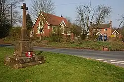
Churchill lub Churchill in Halfshire[1] – wieś w Anglii, w hrabstwie Worcestershire, w dystrykcie Wyre Forest, w civil parish Churchill and Blakedown[2]. Leży 26 km na północ od miasta Worcester i 173 km na północny zachód od Londynu[3]. W 1931 wieś liczyła 201 mieszkańców[4]. Churchill jest wspomniana w Domesday Book (1086) jako Corcehalle[5].
Przypisy
- ↑ History of Churchill, in Wyre Forest and Worcestershire | Place names [online], www.visionofbritain.org.uk [dostęp 2017-11-15].
- ↑ Churchill CP/AP through time | Census tables with data for the Parish-level Unit [online], www.visionofbritain.org.uk [dostęp 2017-11-15].
- ↑ Churchill na mapie. getamap.ordnancesurvey.co.uk. [dostęp 2010-11-27]. (ang.).
- ↑ Churchill CP/AP through time | Population Statistics | Total Population [online], www.visionofbritain.org.uk [dostęp 2017-11-15].
- ↑ The Domesday Book Online - Worcestershire A-D [online], domesdaybook.co.uk [dostęp 2024-04-22].