Stan Tasmania dzieli się na 29 jednostek obszaru samorządu lokalnego (ang. local government area). Występują dwa rodzaje samorządów:
- miasta (ang. cities)
- gminy (ang. municipalities)
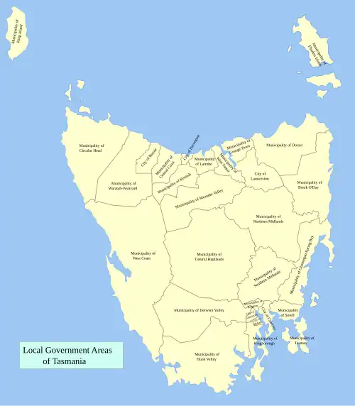 Podział administracyjny Tasmanii
Samorządy
Terytorialne
| Stolica | Powierzchnia
[km²][1] | Populacja
(czerwiec 2006)[2] | Gęstość
zaludnienia |
| Break O’Day | Saint Helens | 3809,8 | 6218 | 1,6 |
| Brighton | Brighton | 168 | 14329 | 85,3 |
| Central Coast | Ulverstone | 931,1 | 21259 | 22,8 |
| Central Highlands | Hamilton | 7976,4 | 2316 | 0,3 |
| Circular Head | Smithton | 4917 | 8188 | 1,7 |
| City of Burnie | Burnie | 618 | 19701 | 31,9 |
| City of Clarence | Rosny Park | 386 | 50808 | 131,6 |
| City of Devonport | Devonport | 116 | 24880 | 214,5 |
| City of Glenorchy | Glenorchy | 120 | 44179 | 368,2 |
| City of Hobart | Hobart | 76,2 | 49556 | 650,3 |
| City of Launceston | Launceston | 1405 | 64620 | 46 |
| Derwent Valley | New Norfolk | 4111 | 9692 | 2,4 |
| Dorset | Scottsdale | 3196 | 7253 | 2,3 |
| Flinders | Whitemark | 1333 | 881 | 0,7 |
| George Town | George Town | 652,6 | 6744 | 10,3 |
| Glamorgan Spring Bay | Triabunna | 2522 | 4329 | 1,7 |
| Huon Valley | Huonville | 5497 | 14442 | 2,6 |
| Kentish | Sheffield | 1187 | 5965 | 5 |
| King Island | Currie | 1100 | 1703 | 1,5 |
| Kingborough | Kingston | 717 | 31706 | 44,2 |
| Latrobe | Latrobe | 550 | 8888 | 16,2 |
| Meander Valley | Westbury | 3821 | 18938 | 5 |
| Northern Midlands | Longford | 5130 | 12505 | 2,4 |
| Sorell | Sorell | 582,6 | 12131 | 20,8 |
| Southern Midlands | Oatlands | 2561 | 5845 | 2,3 |
| Tasman | Nubeena | 660 | 2317 | 3,5 |
| Waratah-Wynyard | Wynyard | 1187 | 13815 | 11,6 |
| West Coast | Zeehan | 9574,5 | 5171 | 0,5 |
| West Tamar | Beaconsfield | 689 | 21543 | 31,3 |
Przypisy
| Ustrój |
- ustrój polityczny Tasmanii
- konstytucja
|
|---|
| Organy władzy |
|
|---|
| Samorząd |
|
|---|