Sainte-Foy-Tarentaise
| miejscowość i gmina | |
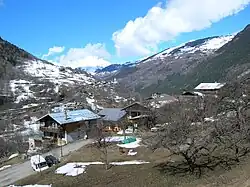 Sainte-Foy-Tarentaise, 2006 | |
| Państwo | |
|---|---|
| Region | |
| Departament | |
| Okręg | |
| Kod INSEE |
73232 |
| Powierzchnia |
107,17 km² |
| Populacja (2017) • liczba ludności |
|
| Kod pocztowy |
73640 |
Położenie na mapie Sabaudii  | |
Położenie na mapie Francji  | |
Położenie na mapie regionu Owernia-Rodan-Alpy  | |
| Strona internetowa | |
Sainte-Foy-Tarentaise – miejscowość i gmina we Francji, w regionie Owernia-Rodan-Alpy, w departamencie Sabaudia. W 2017 roku populacja gminy wynosiła 783 mieszkańców[1]. Na jej obszarze znajduje się w Parc national de la Vanoise[2]. Przez gminę przepływa rzeka Isère[3].
Przypisy
- ↑ Populations légales 2017. INSEE. [dostęp 2020-05-04]. (fr.).
- ↑ Le Parc national de la Vanoise. vanoise-parcnational.fr. [dostęp 2024-08-11]. (fr.).
- ↑ Atlas Routier France 2014. Michelin, 2014, s. 232-235, 249-251. ISBN 978-2-06-719261-4. (fr.).