Hrabstwo Kings (Kalifornia)
| hrabstwo | |||
 | |||
| |||
| Państwo | |||
|---|---|---|---|
| Stan | |||
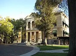
| Siedziba | |||
| Kod statystyczny |
FIPS 6-4: 06031 | ||
| Powierzchnia |
3603,94 km²[1] | ||
| Populacja (2009) • liczba ludności |
| ||
Położenie na mapie Kalifornia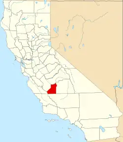 | |||
| 36°04′12″N 119°48′36″W/36,070000 -119,810000 | |||
| Strona internetowa | |||

Hrabstwo Kings (ang. Kings County) – hrabstwo w stanie Kalifornia w Stanach Zjednoczonych. Obszar całkowity hrabstwa obejmuje powierzchnię 1391,49 mil² (3603,94 km²). Według szacunków United States Census Bureau w roku 2009 miało 148 764 mieszkańców[2].
Hrabstwo powstało w 1893 roku[3]. Na jego terenie znajdują się[4]:
- miejscowości – Avenal, Corcoran, Hanford, Lemoore
- CDP – Armona, Grangeville, Hardwick, Home Garden, Kettleman City, Lemoore Station, Stratford,
Przypisy
- ↑ US Census Bureau: Population, Housing Units, Area, and Density: 2000. [dostęp 2012-11-13]. [zarchiwizowane z tego adresu (2015-07-08)]. (ang.).
- 1 2 US Census Bureau: Kings County. Quickfacts. [dostęp 2011-01-14]. (ang.).
- ↑ National Association of Counties: Kings County, CA. [dostęp 2011-01-14]. (ang.).
- ↑ National Association of Counties: Places in Kings County, CA. [dostęp 2011-01-14]. (ang.).
